AZGS Special Paper 12: Landslides along the I-17 corridor from Anthem to Flagstaff
AZGS just released Special Paper #12, Landslide mapping along the Interstate-17 corridor from Anthem to Flagstaff, AZ, on landslide features adjacent to the Interstate-17 (I-17) corridor between Anthem and Flagstaff. Follow this link to review or download Special Paper #12.
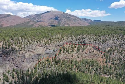
The report hosts 25 figures including three oversized plates (11x17) of the City Boundary (see figure), Maggie Mine, and Runaway Ramp landslides; each plate includes a high-resolution DEM, structural measurements, and annotated topographic profiles.
This report results from months-long mapping of landslide deposits and associated geologic features along a 15-mile-wide strip centered on I-17 from Anthem to Flagstaff – a distance of ~100 miles.
Co-authors J.P. Cook and B.F. Gootee used existing geoscience literature (e.g., Dewitt and others, 2008), detailed topographic data from 2017 aerial orthophotography, and field investigations aided by drone surveys and analysis in their research.
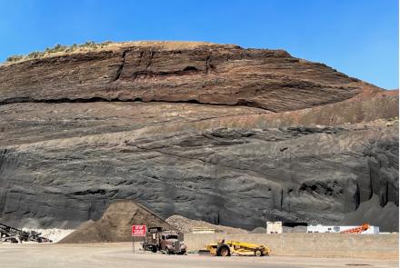
Background. I-17 is the chief corridor between Phoenix and Flagstaff in northern Arizona. Each day more than 50,000 cars (> 18,250,000 cars annually) traverse the Anthem Way - Sunset Point segment. The I-17 corridor winds through hills, mountains, river valleys, and plateaus, slicing through fractured and weathered rocks. Landslides and rock falls potentially threaten I-17 from the Agua Fria River north to the Mogollon Escarpment, 25 miles south of Flagstaff.
We posted four blogs through spring and summer 2020 describing the then ongoing landslide mapping of AZGS’ J.P. Cook and B.F. Gootee. This 38-page report fleshes out that blog content and represents a final report of mapping along the I-17 corridor.
- Part I. Identifying landslide deposits and hazards on the I-17 Corridor
- Part II. Landslides of Black Canyon City and Sunset Point Visitor's Center
- Part III. Landslides of the Black Hills and the Verde Valley
- Part IV. Hy 179 and I-17 on the edge of the Mormon Mountain volcanic field

References
Cook, J.P. and Gootee, B.F., 2021, Landslide mapping along the Interstate-17 corridor from Anthem to Flagstaff, AZ. Arizona Geological Survey Special Paper 12, 38 p.
DeWitt, E., Langenheim, V., Force, E., Vance, R.K., Lindberg, P.A., and Driscoll, R.L., 2008, Geologic map of the Prescott National Forest and the headwaters of the Verde River, Yavapai and Coconino Counties, Arizona: U.S. Geological Survey Scientific Investigations Map 2996, scale 1:100,000, 100-p. pamphlet.