AZGS at work for Arizona: Landslides adjacent to I-17 between Black Canyon City and Sunset Point Rest Area
PART II. Landslides north of Black Canyon City to Sunset Point Rest Stop
This is the second blog post profiling the work of AZGS geoscientists investigating and mapping landslides along U.S. Interstate-17 (I-17) from Anthem, 25 miles north of Phoenix, to Flagstaff in northern Arizona. This is a preliminary report and has not been reviewed for AZGS editorial standards. AZGS will release an Open-File Report with data, digital maps, and final results later this year.
To view Part I. Landslides of the Agua Fria Canyon/Black Canyon City area
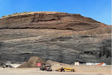
Part I examined landslides exposed in the Agua Fria Canyon northeast of Black Canyon City. Part II focuses on landslides encountered along the 7.5 mile section of I-17 stretching between Black Canyon City north to Sunset Point Vista. Three landslide scarps tower above I-17 to the east (Ferguson and others, 2008, and Natural Hazard in Arizona Viewer (2019). Landslides on this stretch of I-17 displace Tertiary basalts that cap less competent beds of the Miocene Chalk Canyon Formation. These landslides are related to local base-level lowering, or erosion from the Agua Fria and Black Canyon drainages and their tributaries since carving through Black Mesa. Ferguson and others (2008) suspected that the landslides impinging on I-17 were Pleistocene features (~10 ka to ~ 800 ka), but they could not rule out reactivation in the Holocene.
Three of the landslides discussed here crop out adjacent to I-17 at about 1.25 miles (2.0 km), 1.75 miles (2.8 km), 2.75 miles (4.4 km) and 3.75 miles (6.0 km) north of Black Canyon City (see the location figure). A fourth slide, the Black Canyon City slide, situated about ¾ mile north of Black Canyon City and about 2000 feet (610 m) east of I-17, is currently active.
AZGS’s Cook and Gootee are revisiting these landslides and closely examining the original extent of the deposit and their head scarps for evidence of recent activity, e.g., signs of reactivation of the landslide mass, fresh cracks, bulging ground, changes in springs, seeps or evidence of saturated ground, leaning telephone poles, trees, or retaining walls, among other things.

Black Canyon City Landslide
Prof. Ramon Arrowsmith (Arizona State University’s School of Earth and Space Exploration) and his students have been studying and monitoring the active Black Canyon City landslide for more than 20 years. For a synopsis of Ramon’s methodology and research objective at Black Canyon see his blog post of 20 June 2015.
In 2016, Hurien Helmi, a graduate student at Arizona State University, released his M.S. thesis - Characterization of Landslide Geometry and Movement Near Black Canyon City: He concluded: 1) the Black Canyon City landslide was a translational slide – see figure below – with a small rotational component; 2) it has moved down and to the south; 3) total vertical displacement of the landslide mass was ~ 230 feet (70 m); and, 4) the average horizontal landslide velocity is about 0.3 to 2.4 inches (10-60 mm) per year. Helmi hypothesized that landslide reactivation accompanied seasonal rains that increased saturation of the slide mass, which in turn increased landslide mass and lubricated the basal slip surface, promoting downslope movement. Helmi concluded that Black Canyon City landslide was not a threat to the nearby community of Black Canyon City.

The annotated UAV (drone) image illustrates the principal features of the Black Canyon City landslide.
• Perimeter: 1.30 miles (2.1 km)| Area: 0.09 square miles (0.23 km)
• Headscarp: ~1,320 feet (400 m) long on the E-W along long axis
• Landslide width: maximum ~1,650 feet (500 m); typically ~ 1,310 feet (400 m)
• Maximum length: ~ 2,000 feet (610 m) N-S direction; maximum relief ~ 480 feet (146 m)
Prominent tension cracks appear 300 feet (91 m) downslope of the head scarp. These fresh cracks indicate recent movement within the slide mass body. As with other landslides in the Black Canyon area, mass wasting is rooted in the less competent Chalk Canyon Formation capped by competent Tertiary Hickey Formation basalt lava flows.

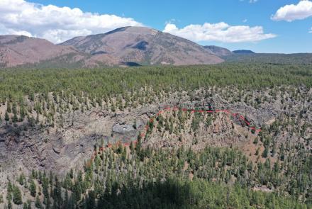
Black Mesa Landslide
The Black Mesa landslide is located 2.7 miles (4.3 km) north of Black Canyon City. The slide mass is largely east of I-17 but underlies the north-bound lane for about 3,100 feet (945 m). It appears to be a primarily translational landslide. With a slide mass perimeter of ~2.1 miles (3.4 km) encompassing 0.21 square miles (0.54 square km), this landslide is significantly larger than the Black Canyon City landslide. From the scarp on the upper slope of Black Mesa to the foot of the slide is a distance of ~0.6 miles (1 km).
We have not observed physical evidence for recent (i.e., historic) movement of the landslide mass. Nonetheless, the landslide mass is inherently less stable than undisturbed deposits and may be subject to failure along planes of weakness and areas modified by I-17 construction. Because the Black Mesa landslide underlies and includes potentially unstable rock and alluvium in close proximity to I-17, it presents a more serious hazard to the highway than the active Black Canyon City

Landslide crowning I-17 Southbound 6 miles north of Black Canyon. A previously unmapped, relatively small landslide has been identified 6 miles (9.7 km) north of Black Canyon City at about 3,100 feet elevation, immediately south of where I-17 southbound begins its descent to the Agua Fria River. Landslide deposits are exposed about 100 feet (30 m) west of south-bound I-17, indicating that this segment of I-17 crosses the main scarp of the landslide. This landslide formed within Tertiary basalt flows (exposed in the roadcut at this location) and underlying Chalk Canyon sediments. A rough measurement shows the landslide mass is ~750 feet (230 m) wide with a perimeter of ~1,800 feet (550 m) and an area of 194,000 square feet (18,000 square m) – an area equivalent to 3.4 football field.

I-17 Sunset Point Rest Area Landslide Complex
Sunset Point Rest Area is located on the western edge of Black Mesa and is utilized by several thousand travelers on I-17 daily. The Sunset Point vista provides spectacular views of a complex of landslide masses along the western escarpment of Black Mesa. The Sunset Point Rest Area landslide complex is about 4.5 miles (7.3 km) long with a perimeter of ~11 miles (17.7 km) encompassing 3.2 square miles (8.3 square km). This is almost certainly the largest landslide complex encountered along I-17.
For UAV pilot Brian Gootee's video: 90-seconds over Sunset Point


The body of the landslide complex, from east to west, is characterized by a series of rubbly basalt ridges separated by flat, fine-grained sediment-filled valleys. Overall, the landslide complex has a hummocky topographic profile with decreasing relief from Black Mesa in the east to Bumble Bee Creek in the west. This lumpy, irregular surface is composed of many landslide blocks in varying degrees of tilt, erosion, and burial by adjacent landslide blocks and colluvium. This landslide complex may be the result of one large landslide event, successive landslides migrating from east to west, or a combination of these processes. The landslide blocks and deposits located just below the edge of Black Mesa and Sunset Point Rest Area are recognizable by distinct, sharply defined basalt ridges which have been displaced from the mesa cap. Moving west, landslide deposits appear more chaotically tilted but subdued in the landscape due to erosion of basalt ridges and infilling of intervening topographic lows. Detailed mapping using LiDAR or high-resolution digital elevation models (DEM) might tease out the number and relative timing of landslide events.

Potential for rockfalls along I-17. There are at least seven engineered roadcuts slicing through granitic and basaltic bedrock on I-17 between Black Canyon City and Black Mesa. Some of these roadcuts have cable netting installed to prevent rockfall from impacting the freeway. According to Leighty (2007), roadcut stability along this stretch of I-17 is a matter of concern. Collapse of fractured bedrock at roadcuts could yield small-volume rockfalls that could impede travel along the north- and south-bound lane. Roadcuts bordering the south-bound lane are fewer in number and lower in height posing less of a threat.
Besides roadcuts, the west escarpment of Black Mesa towers hundreds of feet above I-17 – at slopes of 10- to 30-degrees - for more than two miles (3.2 km) before the road eases onto the Mesa. This segment of I-17 is particularly prone to damaging and life-threatening rockfalls or topples from capping basalt flows.
The next I-17 blog post will focus on landslides near the junction of US60 and I-17 near Camp Verde.
Contributors. AZGS staff contributing to this blog: J.P. Cook, B.F. Gootee, P.A. Pearthree, F.M. Conway
ONLINE RESOURCES
Arizona Geological Survey, 2019, Natural Hazards in Arizona Viewer – Landslide theme.
Arrowsmith, R., 2015, Black Canyon City Structure from Motion UAV results. Active Tectonic Blog.
Bryant, B., 1999, Geologic map of the New River quadrangle and part of the Daisy Mountain quadrangle, Maricopa and Yavapai Counties, Arizona: Arizona Geological Survey Contributed Map 99-C, 1 sheet, scale 1:24,000, 32 pp.
Conway, F.M., 2017, Landslides in Arizona: Just the facts. Arizona Geological Survey Fact Sheet, 2 p.
Ferguson C.A., Gilbert, W.G. and Leighty, R.S., 1998, Geologic map of the New River Mesa 7.5’ Quadrangle, Maricopa County, Arizona: Arizona Geological Survey Open-File Report 98-12, scale 1:24,000, 3 sheets, 29 pp.
Ferguson, Charles A., Haddad, David E., Johnson, Brad J., Guynn, Jerome L., Spencer, Jon E., Eddy, David L., and Clark, Ryan J., 2008, Geologic Map of the east half of the Black Canyon City 7.5’ Quadrangle and the west half of the Squaw Creek Mesa 7.5’ Quadrangle, Maricopa County, Arizona: Arizona Geological Survey Digital Geologic Map DGM-64, version 1.0, map scale 1:24,000, 27 p. and 1 map sheet.
Helmi, H., 2016, Characterization of Landslide Geometry and Movement Near Black Canyon City, Arizona. Arizona State University Masters Thesis, 122 p.
Leighty, R.S., 2007, Geologic map of the Black Canyon City area and Squaw Creek Mesa area central Arizona: Arizona Geological Survey Contributed Map CM-07-A, scale 1:24,000, 46 pp.
Youberg, A. & others, Building a Statewide Landslide Inventory in Arizona. Geological Society of America 2015 Annual Meeting, Poster presentation.